
Places to walk...GUIDES, MAPS, BOOKS, IDEAS
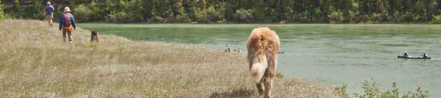
Walkers like variety—easy, hard, short, long, steep, flat, open, in the bush, ..... and while the trails around our neighbourhoods are the most used of our repertoire of trails, we're often looking for different routes, different places to walk.
Whitehorse, the wilderness city. A collection of walking ideas is about making Whitehorse a great walking city. Included are over 75 circular walks, almost 600 km of walks to tempt both tourists and locals. Check often as updates happen frequently.
Walking communities has maps, Parks, interpreted trails and other walking ideas outside Whitehorse.
Possible spots around town for those with walking, mobility issues
November 19, 2021. Shorter loop walks around town
August 4, 2020. There's people who have very limited walking abilities — wheelchair, walker, stroller, Parkinsons, little kids, dementia, Alzheimers,and those with bad backs, hips, knees. Many just want to get outside and into a peaceful, awesome place.
Some constraints are it must be short (about a 1-1.5 km return), moderately level, good footing – a good surface. — that's a hard call. Wheelchair and walker users might like paved. Many would like crushed gravel or wood chips. Some can't walk on pavement at all!!
I've started a short list of places. (also see Short Loop Walks) Without a Yukon Council on Disability, I'm not sure how to move this along except to continue to find new places.
- Schwatka Lake East is interesting. Drive-in access, sections of flat, but also roots so not really accessible, but good for weaker walkers. Loops can use the yellow trail on the east side of the road. Grubby area at times with ltter, party debris and campfire remenants — but very scenic. Here's a set of loops to try. A sieved crushed gravel trail could help preserve a natural character.
- Tàgá shrō / Wolf Creek Trail, Wolf Creek Campground. 1.7 km return through delightful forest: meandering packed fine gravel trail with benches, interpretation; viewing deck at 750 m and picnic table at 850 m overlooking the Yukon River valley. There's a nice parking area right at the trailhead inside the campground.
- Hospital Road. Along the fence above Wickstrom Road, behind the old hospital row buildings, is a nice area with views across to the Waterfront Trail. Perhaps it could be treated as a park and with picnic tables, benches and a sieved crushed gravel pathway. It's easily accessible from the Hospital, Thompson Centre, Crocus Ridge residence.
- Wickstrom Road, from the parking outlook on the river, just past the back entrance ramp to the Hospital. Walk north about 700m on Wickstrom until the second hill, just around the last houses. A quiet stretch of road, with the river alongside. 1.4 km return, or get picked up at the church parking lot for a 1-way walk.
- Miles Canyon Road. Just before climbing the hill there's parking at the gate. It's a nice short walk along the river on a gravel road. More to come here.
- Old WP&YR track bed off the Miles Canyon Road near the highway: follow just beside the railway tracks, then almost immediately go left along the old service road, then the old track bed until it opens up above Miles Canyon, just above the Hepburn Tranway. Views of Schwatka Lake and the river. Very nice. A map will come!
- The Millennium Trail is of course a great option. Lots of places to get on and off. This past year the city started clearing it in the winter. Map to come. It's not a great trail for people with foot problems as it's paved.
- Bert Law Park, accessed through Robert Service Campground and the Millennium Trail, is a treasure. A crushed gravel path would make it much more accessible.
- At the fish hatchery, by the Rock the River gates are lots of benches, people walking, fishing, kayaking, hanging out. The islands in the river have lots of gulls and, occasionally, eagles. There's a section of Macaulay Tramway which is nice. There's a number of dirt trails throughout. Area map to come and suggestion for a small bridge.
- From the fish hatchery to Robert Campbell bridge is another neat walk. Lots of benches, short-cur trails to bail if too tired. Hopefully the skateboard park has a number of designated accessible parking spots. Map to come.
- Rotary Centennial Bridge to dam is a nice 1.3 km paved out-and-back with a hill for exercise. Park at the bridge and follow the paved path to the fish ladder. Continue up the sloped road to the edge of Schwatka Lake. Great views of the spillway and the white water by the fish ladder. Sometimes there's kayaks to watch.
- Lower Escarpment Trail from Black Street almost to Hawkins Street
- Pioneer Cemetery at Wood and 5th has a .5 km paved loop and lots of grass. Always a thoughtful place.
- Shipyards Park has a paved oval and Thursdays in the summer, a farmer's market
- Downtown's Waterfront Trail from Robert Campbell Bridge to Tàgä Shrō Station opposite the big box stores at Marwell
- Watch the birds on the river beside Industrial Road. Between Tàgä Shrō Station and past Walmart is a 600-m stretch of gravelly packed surface along the river. Access is from Tàgä Shrō Station, behind the bus stop, or off the road near Walmart as the trail bends away from the road. There's an interpretive panel and bench.
- The city's paved connector trails. Maps to come
- Upper Riverdale Trail/Grey Mountain Road has a few nice loops. Map to come.
- Whistlebend Perimeter Trail. Map to come
- Airport Perimeter Trail from Range Road parking lot to Black Street Stairs is paved
- South end of airport opposite the weigh scales: Park and follow the fence down a messy rubbly road. At the bottom, follow along the fence as far as you can. Great views.
- The walking track at the Canada Games Centre. Soft plastic surface.
- FH Collins' new running track. Hmmm. What's this like?
- Grey Mountain Road cemetery has lots of possibilities.
- Mount Sima road, shortly after first quarry are cliffs of a lovely exposure of Miles Canyon Basalt with a bench overlooking a small pond. Exquisite views. Rough road. Map to come.
other MAPS/Walking areas
- Whitehorse Recreational Trail Guide
- Contagious Mountain Bike Club (facebook page) sells a good map (version 3?) of Grey Mountain trails.
- Yukon Fat Bike's Facebook page has lots of trail discussions
- Whitehorse Cross Country Ski Club ski trails; also, Snowshoe, Hike: Mount McIntyre Recreation Area
- Yukon Trail Marathon route
- Yukon Wildlife Preserve: Self-guided walking tour with an informative trail guide and a map indicating the walking routes and locations of the animals; a 2.5 or 5 km loop; must be conducted during daylight hours; last summer entry is at 4 pm and recommended last winter entry is at 2 pm. Fee.
- Yukon Conservation Society, Friends of McIntyre Creek have 4 trails at McIntyre Creek
- City GIS open data great resource! Open KMLs with Google Earth
- Yukon Environment mapping is another great resource, although data is presently only as PDFs not as KMLs
- Skyline air photo locator
- Geomatics Yukon
- GeoYukon is highways and Public Works on-line mapping
- For free topographic maps of Canada go to Maptown and find the map number you would like: Then, go to the Index of Canadian Topo maps, choose the map number and download.
- Yukon Stocked Lakes Program
Orienteering resources
- Yukon Orienteering; out of date overview map
- maps world of o zoom in to whitehorse and there's lots to look at
- attackpoint.org is another place to cruise. Search on Whitehorse
Interpreted trails, walks
- Boreal World Trail at the College (Find a link!)
- Wolf Creek Trail
- Gunnar Nilsson & Mickey Lammers Research Forest has nice interpreted trails (map).
- Yukon Conservation Society has a weekly summer nature hike at Miles Canyon
- Making an interpretive hike on Sima
books/booklets
- Enjoying Whitehorse trails, A guide to the Yukon River trails to Schwatka Lake, Miles Canyon and Canyon City, 2000, YUKON ENERGY (German, French versions)
- Viewing Whitehorse from above, A guide to Haeckel Hill • Thay T'äw, 2002, YUKON ENERGY
- The Yukon Hiking Guide - Curtis Vos
- Hikes and Bikes – Yukon Conservation Society
Hikes and Bikes Waypoints
WEBSITES
- yukonhiking.ca directions, GPS routes, mostly out of town... See also their Facebook page
- yukonbiking.ca maps of lots of trails; addressed to mountain bikers but the trails are mostly public I believe
- BikeMaps
- Strava
- trailpeak – a community-driven trail site (search on Yukon, sort by community)
- paraglidingearth and paraglidingmap
- Whitehorse caches to look for.
- rockclimbing.com has a number of places one could walk in to.
- Everytrail.com
- Clubtread
- Trailforks
- mapmyhike
- Trans Canada Trail
Blogs
- The ExploreNorth Blog, Living in the North, Exploring the World
Kwanlin Dun First Nation
- Lands and resources: Community, site-specific and rural settlement land maps and land claim agreement.
Ta'an Kwäch'än
Yukon.cais a start of YG informations such as campgrounds.
CITY OF WHITEHORSE
- Millennium Trail map
- 2012 ATV trail map
- Snowmobile trail map
- Whitehorse, the wilderness city: a guide to the popular trails of Whitehorse, 2008
- Commuter cycling map 2012
- Active transportation commuter network improvements, 2015
- Playgrounds
- Skating rinks
- Disc golf
- Transit maps
- Zoning Bylaw maps
Winter walking
- Snow and ice control policy Appendix C has a map
- The paved two-mile hill is ploughed and sanded
- Walk Canada Games Center's 215-m indoor track
(M-F: 5:30am - 10pm; S,S: 7am - 10pm)
Whitehorse Visitor Information Centre
email; 1-867-667-3084, Fax: 1-867-393-6351
100, Hanson St (at 2nd Avenue)
- Summer: 8:00 a.m. to 8:00 p.m daily.
- Fall/Winter: Monday to Friday from 8:30 a.m. to 5:00 p.m. (closed during noon hour); Saturday 10:00 a.m. to 2:00 p.m.
whitehorsewalks.com maps
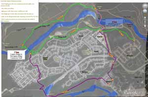
I'm making a set of PDF maps based on an image of the entire city with trails, developed in Google Earth. Zoom in using the PDF zoom tool. Start with areas you know, like your neighbourhood, then explore. Think about trails which you've hiked, which ones you'd recommend that visitors can safely do. If we ever get the community energy to have a walking festival here, which walks would you recommend? Here's the Legend, and some trail discussion, including a start of a named trail database.
- Walking in Whitehorse(2018): playgrounds, public right-of-ways, trails+names, viewpoints, motorized trails...
- Making walking better: suggestions such as bridges, boardwalks, trail repair, connector trails needed...
- Development and walking: future development, commercial, public utility, the urban containment boundary (UCB) and the future UCB, so we know a bit more about where our city may grow...
- The 5 OCP parks: Thinking about walking trails, what do we want our parks to be like?
- Whitehorse Corridor – Alaska Highway project: Highway corridor map, Overview/legend and highway intersections. The highway has the potential to encourage more walking, or to discourage it.
NOTE: The maps are fairly detailed prototypes: 65 x 28 inches ~7-8mb. Don't try to print them.
The maps are created for discussion. They are not provided to claim safe trails. No responsibility of conditions or accuracy is implied by presenting these maps. Observations, corrections and additions are very welcome. Improvements will come as people proof them, by walking them!
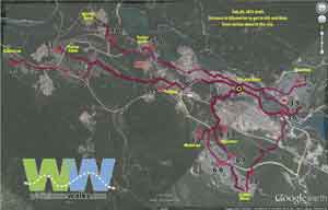
Walks, giving distances between points and linking trails to get to other neighbourhoods. There's overlap as I work on seeing best way of presenting this data. (Think of walking about 4 km per hour for a moderate pace.)
 With our new trail network that the city has built at the Whitehorse Cross Country Ski Club, possibilities abound. See Mount McIntyre Recreation Area: all-season walking trails. Also read: Mount McIntyre Recreation Area
- Transportation Management Demand Plan's
 desire to get people out of their cars. To me, that means walking. If I was walking to work I'd want to know the fastest routes and the more interesting alternatives. To the right is a first draft, discussed in my Transportation Demand Management Plan submission.
 - A walkable community — 5 city center trail loops:
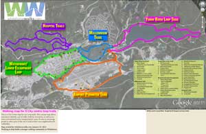

attractions along each of the loops distances between points - Active Transportation routes Draft 1, discussion
- Above-the-airport Draft 2
- Downtown/Riverdale Draft 2
- McIntyre Creek
- City center draft 1
- Take a look at my ideas for better walking page for other walking ideas.

