A walker's look at downtown–Marwell
TOC this page
- Getting to 4th and Main
- Yukon River Corridor Trail
- Marwell wetlands, Industrial area
- Coming down from Mountainview Drive
- Coming down from Takhini
- Spook Creek & lower escarpment trails
- Ball diamond stairs
- Main Street pedestrian bridge
- Taxing under-used land
- 5 city centre loop trails and walking tourism
- OCP planning/brainstorming maps
This page was created as a background for Council's look at downtown and Marwell. The intention is to ensure that walking is kept in focus as Council hears about our city's possibilities. Note that the map images below are each linked to larger images.
Think about walking if you live downtown or in the Range Road, Takhini areas: important walking destinations are the escarpment and along the waterfront. While these are nice walks, people like variety and will want to walk other places—without driving. Here's some ideas...
Jan 8. Added Takhini and Range Road's 2009 brainstorming maps from the lead-up to the 2010 OCP.
Getting to 4th and Main
We live in interesting times. Today the vehicle rules and health studies say we are not active enough. So how can we get people thinking differently? One solution is walking. Look at the popularity of the Millennium Trail, the Rotary Centennial Bridge. Interesting trails will become destinations, encouraging people to expand their horizons.
But before people set out on a walk they sometimes want to know how far, how long, where to go. So I made this map with the corner of 4th and Main as a destination. Generally I chose to follow paved trails if they are obviously faster (shorter). But, walking alongside roads is boring, noisy, smelly, so where it was possible, I chose cleaner air, quieter, more interesting scenic routes.
Think of walking about 4 km per hour for a moderate pace.

The Yukon River Corridor Trail
In 2003, Kwanlin Dün First Nation published a book Back to the river. In 2013, Whitehorse, an Illustrated History was pulished. Both stories have much to say about the importance of our river in the lives of the people who lived here. As one would expect, a traditional trading trail once ran from Marsh Lake to Lake Laberge.
Could we have a trail that runs along the river through the city? To do this we need to look ahead and plan. Zoning, land use rules are critical. The Yukon River Corridor Trail depends on trail decisions made for the Marwell area. With important segments of this proposed trail passing over Kwanlin Dun lands, their participation is critical.
One day, if we plan it right, we will be able to walk along the river, from the Yukon River Bridge to the Takhini River Bridge. While many parts of this route exist, the area from downtown through Marwell is still only an vision, an opportunity for the city. On the above map, green are existing trails or routes, orange are areas that need to be looked at.

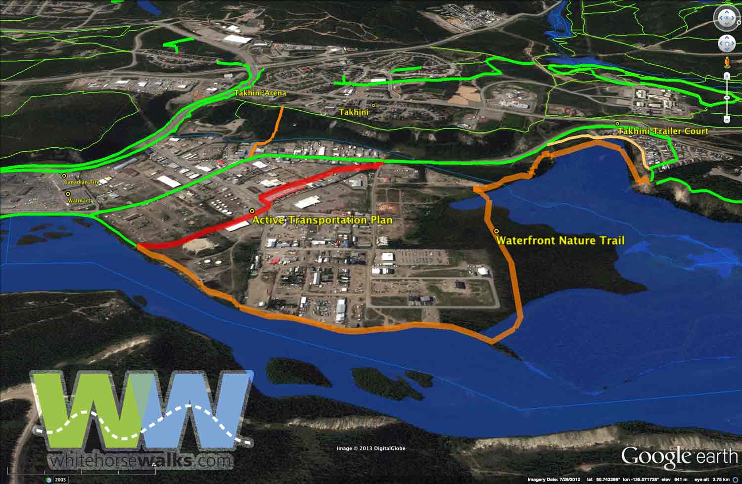
Marwell wetlands and industrial area
Marwell is one of Whitehorse's oldest industrial areas. It's right next door to a very large scenic wetland. The city is growing downtown with seniors' residences, condominiums and a generally revitalized downtown and waterfront. But industrial development has also grown dramatically over the past decades, especially in the north end of downtown and in Marwell.
On the above map, the current way through the Industrial area (green trail) follows Industrial Road as it turns into Mountainview Drive; this way is quite unappealing as a walking route, likely also as a cycling route. The city's active transportation plan's proposed route, shown in red, is through the heart of the industrial area. This route will be great for people in a hurry, such as those bicycling to and from work—but not so nice for scenic walks.
A significant portion of the orange route marked as 'Waterfront Nature Trail' goes through KDFN land and will obviously be subject to its needs and timelines. As it goes along the edge of the wetland and the edge of the Yukon River, it would be far more interesting for recreational walkers and tourists. Dog walkers from the animal shelter would rejoice in not having to walk on a dusty gravel road with lots of commercial traffic.
Is it possible to stay along the river and cross Marwell Creek with a bridge and then a switchback up the bluffs. This would be a very popular route!
With the new KDFN Cultural Centre on the waterfront, river walks will become increasingly important. With the large wetland complex just past Marwell, only 3 km downstream, the opportunity to combine walks and interpretation presents itself as an interesting way of sharing First Nation culture.
As the Marwell contaminated site is cleaned up, zoning for a trail along the river should be in place for all future planning. Likewise for the other waterfront industrial lots, the city should be insuring that a waterfront trail can go through the area. Read more: They've started to clean up contaminated land along the river but what is next?

Coming down from Mountainview Drive
The view above shows trails and routes as the green line from Takhini Trailer Court on Range Road and down Mountainview Drive. People living along Range Road and the new Whistle Bend will need much more encouragement to think about walking to town than using the current setup.
The light yellowish-orange route offers one suggested way of avoiding some of the road. The thicker orange shows a possible route that would be much nicer. Recent work on the Copper Ridge to Porcupine Ridge Trail shows what great things our city's trail crew can accomplish!
Read more here about Range Road North neighbourhood planning currently underway. The next event, the Range Road North Design Workshop, has been scheduled for January 21-23 at the Kwanlin Dun Cultural Centre.
Coming down from Takhini
In the above map, trails descend the escarpment from behind the Takhini Arena. At the bottom the one shown in orange crosses Marwell Creek. A small simple footbridge would make this route much more inviting for locals to come down and access the waterfront. Presently, a few pallettes are strewn about to enable a dry crossing. For those walking to work, this could be much more inviting than walking along Two-mile Hill, Fourth.... Again, signs and a nice physical feature like a bridge will encourage even more use.

Spook Creek & Lower Escarpment trails
A necessary trail downtown is a connection from the Black Street stairs to the waterfront. One neat solution would be to extend the Lower Escarpment Trail to the intersection of Fourth and Second avenues, and to create a Spook Creek Trail to cross to the Waterfront Trail at Spook Creek Station. These connections are shown in red. Both road crossings are at traffic lights with pedestrian signals.
Let's make the Spook Creek Trail/parkette a paved wheelchair-accessible trail, complete with flowers, trees, benches, lights. With the large industrial presence here, landowners may well wish to chip in on a beautification initiative. This connection to a Lower Escarpment Trail could be a way to lure the Walmart campers into our city.


Left map: Proposed Rogers Street stairs. Right map: Proposed ball diamond stairs.
Ball Diamond Stairs
Having stairs behind the ball diamonds across from Yukon Energy would open up a host of trail possibilities and encourage much broader walking participation among both downtown and Riverdale walkers. Additionally, it would formalize the above-the-airport neighbourhood's route down to the Millennium Trail.
It would seem that with tight city finances, the Rogers Street staircase wouldn't be getting as much bang for the buck as it should! Read more here.

Main Street pedestrian bridge
A third pedestrian bridge (orange line) across the Yukon River from downtown to the hospital would give the many workers on Hospital Road an easy, quick way of having lunch downtown, without driving. It would give people downtown fast access to the hospital trail network. It would add to the presence of the new wharf and encourage tourists to explore a bit more.
The bridge would be a bit longer than the Rotary Centennial Bridge and would bring new life to the downtown area. This would also extend the loops created by the Rotary Centennial and Robert E. Lowe footbridges.
Red lines are the city's proposed motorized trails, thin green are aspects of a possible quiet Hospital Trail network with a major starting point being the hospital. Read more here about the hospital walking trails and here for more information about the East Yukon River motorized multi-use trail network draft plan.
Taxing under-used land
There needs to be some penalty taxation rate for the large amount of real estate downtown that is undeveloped. It is a waste of valuable space, it forces the city to look at spreading out into greenspaces, and most of all, makes a lot of downtown look like a wasteland. Many of these properties are eyesores!


Left map: attractions along the way. Right map: walking map showing distances.
5 city centre loop trails and walking tourism
Whitehorse is well positioned to capitalize on a niche tourism product: walking. This would be a core part of a Stay-another-day strategy. This network of trails and routes is walkable at this time, but as a tourist I'd be pleased to see it improved. As a senior, I'd want it better; as a hesitant walker I'd want it better. The great thing is that these are mostly non-motorized trails and accessible without a car from downtown. Another plus is some pieces are paved and stroller/wheelchair friendly.
What's really missing is promotion: signs, maps, a community taking ownership, converting pieces of trails into an identifying city feature! Read more here: 5 City centre loop trail
A big side bonus of a walking trail system for tourists is that the ones who benefit most are locals — in this case, people living downtown. With the growth of condominiums, there are increasing number of people living downtown. The waterfront trail stops at Walmart. Most trails downtown are paved. Walking can get boring. Thinking about these 5 city centre loop trails, and their connections to areas such as above-the-airport, McIntyre Creek, Mount McIntyre Recreation Area, Chadburn Lake, will satisfy even the more adventurous recreational walkers.
Also see Yukon Energy's Enjoying Whitehorse trails, A guide to the Yukon River trails to Schwatka Lake, Miles Canyon and Canyon City, 2000
This walking tourism page looks at the benefits of developing a walking tourism strategy, both as a Whitehorse walker, but more specifically, with a Yukon-wide perspective.


Area planning process from the lead-up to the 2010 OCP
 The Walking map shown on the right shows connections with above-the-airport neighbourhoods. Downtown/Riverdale Draft 2 focuses on Riverdale and downtown and PG/PR zoning connections. A more up-to-date version is coming soon.

