Re-developing the Marwell area for people on foot
May 19, 2013. Cleaning up a wartime-era mess talks about current progress in site clean-up.
Development of a Fish and Fish Habitat GIS talks about the Marwell area and Spook Creek.

Marwell wetlands and industrial area
Think about walking if you live downtown: places are the airport and along the waterfront. While the waterfront trail towards Rotary Park is a nice walk, people like variety and will quickly be wanting to walk other places. Likewise, with the new KDFN Cultural Centre on the waterfront, river walks will become increasingly important. With the large wetland complex just past Marwell, only 3 km downstream, the opportunity to combine walks and interpretation presents itself as an interesting way of sharing First Nation culture.
Marwell is one of Whitehorse's oldest industrial areas. It's right next door to a very large scenic wetlands. The city is growing downtown with seniors' residences, condominiums and a generally revitalized downtown and waterfront. But industrial development has also grown dramatically over the past decades, especially in the north end of downtown and in Marwell.
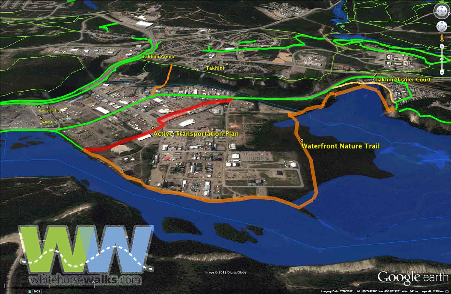
The view above shows trails and routes as green lines. The current route (green) follows Mountainview Drive as it turns into Industrial Road; this way is quite unappealing as a walking route, likely also as a cycling route.
The city's active transportation plan's proposed route, shown in red, is through the heart of the industrial area. This route will be great for people in a hurry, such as those bicycling to and from work—but not so nice for scenic walks.
Now, let's look at the orange route marked as 'Waterfront Nature Trail'. Here's an opportunity for wildlife viewing, a trail along the river for recreational walkers and interpretation. A significant portion of this goes through KDFN land and will obviously be subject to its needs and timelines. As this route goes along the edge of the wetland and the edge of the Yukon River, it will be far more interesting for recreational walkers and tourists. Dog walkers from the animal shelter in Marwell will rejoice in not having to walk on a dusty gravel road.
What is the status of the land along the river?
The waterfront trail needs to extend alongside the river through the Marwell industrial area. The edge of the contaminated site should be zoned to allow a trail. From a walking perspective, a large number of users along here will be recreational walkers, people living in the new condominiums, tourists walking the Yukon River Trail. Their needs will be better met through staying alongside the river and wetlands as much as possible.
There are a number of territorial- and city-owned lots. In the short term, the City proposes an Active Transportation Trail to allow bypassing Copper Road. What is its status?
Yukon Envirothon has a project: Marwell Study Area: background and student challenge
When we also think about a Yukon River Corridor Trail, some sort of zoning should be in place that signals the city's desire to reclaim a waterfront trail. As the Marwell contaminated site is cleaned up, the space for a trail should be in place for all future planning. Likewise for the other waterfront industrial lots, the city should be insuring that a waterfront trail can go through the area.
 The Mountainview – Range Road trails depends on what happens as residents try to walk towards downtown.
Coming down from Takhini
In the above map, trails (thin green) descend the escarpment from around the Takhini Arena. At the bottom they cross Marwell Creek. A small simple footbridge would make this route much more inviting for locals to come down and access the waterfront. For those walking to work, this could be much more inviting than walking along Two-mile Hill, Fourth....

