Should we make safe highway crossings, or should we just run faster?
The Territorial Government wants to make the Alaska Highway mostly 4 lanes as it passes through town. This page is my walker's point of view looking at crossing the proposed road. See press release: Whitehorse corridor functional plan; project website; maps and documents: Resources
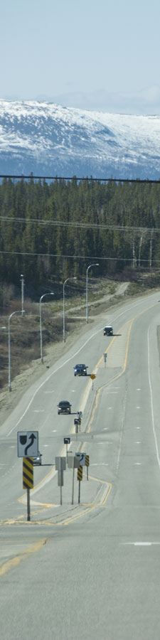
My question to the project team was, "Where can I cross the road?" Their answer: "Pedestrian crossings will be provided at signalized intersections."
There will be 7 traffic lights: South Access, Hillcrest Dr, Two Mile Hill, KK, Birch/15th, Wann Rd, MacDonald Rd. Really?! That's it?
May 15, 2015. Just sent in my input to the Whitehorse Corridor – Alaska Highway project: My submission is in 3 parts: Input, Map, and highway intersections.
I hope I've made the case that active transportation walking is different than recreational walking, and that the pedestrian guidelines don't seem to capture this. It should come down to Whitehorse is an active living place and the highway has the potential to encourage more walking, or to discourage it.
Whitehorsewalks looks at the project
Seven lights in 40 km. OK. I counted about 46 intersections larger than a small driveway-stye entrance. So looks like 39 intersections where there's no allowances for pedestrians. As a walking person, I see it that for our $200,000,000 we only get 7 intersections with pedestrian crossings. Not much of a bargain. Our city's desire is an active healthy population that walks recreationally as well as for active transportation. Think what Whitehorse will like be in 20 years if our population doubles. Is the highway plan for each intersection ok for pedestrians, especially where area are zoned to allow residential growth?
This shows highway intersections, speed limits and distance between intersections. The number of each intersection refers to maps in: 54 segment maps — the entire proposed project.
I made the issues map by putting the location of each of the 46 intersections onto background maps. The next 3 maps better show the layers I used:
- Walking in Whitehorse map shows trail and destinations: playgrounds, rinks, schools,...
- Walking in Whitehorse map shows the 5 OCP parks: as a Park nears the highway, or crosses it as MacIntyre Creek Park and Wolf Creek do, both people and wildlife need to be able to cross the highway.
- Walking in Whitehorse development map shows planning, or should I say Zoning. Based on the Zoning Bylaw it shows — future development tan: FD ; purple: FN -FD; dark blue: PS; Sky blue: PU; Red: CA, CH, CR, FN , IA, IH , IQ, IS.
See Places to walk, guides, maps for versions of the Walking in Whitehorse map without the highway intersection stuff, and the legend.
Background
The percent of active or moderately active people in 2011 shows Yukon the highest in Canada. If the highway plan is looking 20 years into the future as it plans its construction process, shouldn't we as a city be looking these same 20 years for walkers? While active transportation is a city goal, recreational walking is a reality. And these walkers are the low-hanging fruit for active transportation. We want to encourage more walkers! If the city had a walking strategy, then surely a trail along the Yukon River will be a goal. It would be a major destination for each neighbourhood on the west side of the highway throughout the city. Note that where I refer to walkers using trails, obviously other trail users will be on the trails such as people on bicycles.
I think it's important that we not lose sight of the city's Transportation Demand Management ideas, their Economic Development ideas, their Sustainable city ideas. We should be working to common goals, after all most highway planners in the Yukon Government live in Whitehorse!
The need for pedestrian crossings is based on formulas that seem to address more active transportation than recreational walking. But our city is a different animal than a model built on southern ideals used to calculate highway needs of cars. We're a very spread out city.
Mathematically, their engineers are justified in ignoring pedestrians. But is that what we want as a city? Their calculations use 7 hour days, 100 m separation between intersections; Whitehorse has long summer days and many (most) of our highway intersections are hundreds of metres apart. Calculations around pedestrian crossings seem to be around 1 km of highway, a 20 min walk. But Whitehorse walkers are more active than that — we're hikers as well as outdoorsy people who often take long walks. Case in point: McIntyre, Grainger residents walking down by the Salvation Army around the end of the airport; easily 4 km one way, and back is uphils and a long staircase.
Some say that bigger roads won't help: What's up with that: Building bigger roads actually makes traffic worse: our traffic jams will be getting into downtown!
Many feel that this is massive overkill for our little community and the money could be better spent elsewhere: Smothering a problem with money.
Can we stop this? Do we even want to? Nothing wrong with safer roads. And it sure gets difficult getting onto the Alaska Highway from Hillcrest at times. They want to change the Two Mile Hill intersection, yet again, making it 2 lanes turning from Two Mile Hill towards the airport. Maybe they'll fix the crazy dangerous sight lines at the south access for traffic turning from Hamilton Boulevard towards the airport.
It's interesting watching the senate entitlement process play out for some of the anointed senators. I think to myself, a highway also seems to have a sense of entitlement. The need that vehicles go quickly and safely through a city is the thing of importance. That it also creates a huge barrier within the city seems wrong.
Highway planners are primarily focussed on efficiency for vehicles and no accidents, either between vehicles or other road users such as pedestrians and bicycles. So now the planners are asking the public if there was anything they missed. You know where they're doing an amazing job tracking infrastructure? The Yukon A sparsely populated Canadian territory is beating out big-city interactives with a public-engagement plan combining the best of high and low tech.
Looking at roads from the point of view of non-cars can be done. How do we protect New York City's pedestrians? The goal was to determine how to make the intersection safer for pedestrians without significantly reducing the almighty "level of service."
To me it looks like raised islands are one answer and another idea would be a divided highway with a gravel center island, sort of like in Riverdale or on parts of Hamilton Blvd. Or islands could be paved as in the photo on this page, or cheaper would be a gravel median island with plantings like Hamilton Blvd.
Jane's Walk is a movement of free, citizen-led walking tours inspired by Jane Jacobs. The walks get people to tell stories about their communities, explore their cities, and connect with neighbours. Wouldn't it be neat if people led walks in the city that used intersections on the Alaska Highway where no pedestrian crossings are proposed!
Peter