The Hepburn Tramway
2017. (Small addendum page).
May 15, 2015. Hepburn Tramway - Escarpment Trail, 4.2 km. a 1-page hike description.
May 3, 2014. Jane's Walk coming up...cancelled. Plans for making the trail at Miles Canyon more suitable for a broader group have fallen through. For now, there's a section that requires a bit of tricky hiking. Email me if you want to walk the trail and I'll happily arrange this at other times.

 The PDF Forgotten Trails, walking the Hepburn Tramway is the back story. (Viewing the maps and photos on screen is nicer than printing the PDF.)
- The 1898 Hepburn Tramway is a large artifact that can't be rescued and moved into a museum; however, the route would be a great Historical Walk. Designating this would make a strong statement about the importance of walking. See also Yukon Walking Strategy.
- The Hepburn Tramway used horse-drawn trams, necessitating an easy grade for the horses to get over the riverside hills. By restoring the tramway route with its original grade, we'll have a walk doable even by those with mobility issues ( such as elders, those with joint issues, small kids.)
- The Hepburn Tramway offers an incredible active transportation–recreation route, connecting the Millennium and Waterfront trails to Whitehorse South neighbourhoods, along an important section of the Yukon River.
- From The case for improving health outcomes through placemaking, 2016, by Project for Public Spaces, Inc.
- Placemaking helps fulfill local community needs and visions for a place—residents meaningfully engaged in conceiving, planning, and implementing improvements.
- Placemaking projects highlight local assets ... the showcasing of historic or natural features.
- Placemaking brings diverse community members together, facilitating social interaction and engagement through the space's design, programming, amenities, and the planning process itself.
- Placemaking fosters quality public spaces that help people feel connected to the place and to the greater community.
2016 Innovation, Education and Community Engagement Award.
Dear Peter,
On behalf of the Board of Directors of the Yukon Historical and Museums Association (YHMA), I am pleased to inform you that you have been nominated and selected to receive the 2016 Innovation, Education and Community Engagement Award.
The award recognizes the leadership, and the outstanding contribution to Yukon heritage preservation, in your recent research and website publication, Forgotten Trails: Walking the Hepburn Tramway. We applaud your work as it is fueled by a desire to value, protect and develop aspects of our local history.
Sally Robinson President, Yukon Historical and Museums Society. CBC interview with Sandi Coleman
Creating a Historical Walking Trail
- Most important thing to help: contact Mayor and Council to say you think this is a worthwhile idea.
- It's ambitious, a mix of easy and hard opportunities — building interest and awareness will take time.
- We need to get organizations involved, such as museums, and groups like runners and bicyclists, schools...
- We need to get some sections usable for immediate use, and improve harder sections as practical.
- At first, there should be minimum repairs (brushing, some shovel work, re-benching) to the Hepburn Tramway trail to make it safely walkable. There are spots where the original rails are still visible. Preservation and interpretation will never be easier than now! Tasks like restoring the Goat Trail and creating a Schwatka Lake Promenade will take time and broader participation.
- Standards and guidelines for the conservation of historic places in Canada There's a good summary, "The Standards", on the main page, as well as a link to large document.
- Introductory walks can be offered so people better understand the tramway's possibilities.
- There could be guided walks covering topics such as melting glacial lakes and the Yukon River; use as a First Nation bypass trail; early portages; forest regrowth after a major forest fire; the Hepburn Tramway and spur trails; the Alaska Highway's American Laundry; and pump houses for industrial projects.
- Another opportunity is to tell more about the Macaulay Tramway. Can we compile all the photos of both tramways and the canyon/rapids area into one place. Can we resolve conflicting stories as to start dates of the two tramways?
- The 1899 telegraph line which parallels the tramway is another topic that could be expanded. It was and still is on the west side. How did this relate to the telegraph office at Canyon City?
- Is there any aspect that Canada 150 funding could help?
Processes that can affect a Historical Walking Trail
- On Monday, March 27, Mayor and Council will be voting on a proposal to build a quarry at Miles Canyon. Here's a backgrounder, Building a quarry at Miles Canyon, about why I think this should be voted down.
- Obviously this needs to be worked through the City's trail processes.
- A 1963 CMHC Report said "It is recommended that an area referred to as the Chadburn Lakes - Miles Canyon area, should be set aside as a park reserve and provision made for its appropriate development by the territorial or municipal governments:
"This area contains some of the most attractive lakes in the Region, is well treed and rises sharply on the east providing a spectacular backdrop to the Yukon Valley. It is within 5-10 minutes drive from the lower townsite via a new road built in 1961 and can offer excellent facilities for picknicking, camping and various water sports. Miles Canyon, as well as providing dramatic scenery, has rich historical associations with the Trail of '98 and is perhaps the most attractive area in Metropolitan Whitehorse. "
- The tramway used to be protected by being almost totally within the 1970 Chadburn Lake Park Reserve (land was withdrawn from disposal as it is required for public purposes); later the reserve was cancelled with ever-changing OCPs protecting part of it. The City will be updating the OCP this/next year.
- City's Whitehorse South Trail Task Force: Opportunities for Whitehorse South recreation are challenging. The task force looked at the community desire for a Yukon River Trail. With a switchback from Fox Haven to Fox Farm Road creating a continuous path to Wolf Creek Campground, Miles Canyon will become an important area destination. What choices will be made that will affect the Hepburn Tramway? Are there alternatives to designating the area between the tramway and the river as a motorized dirt bike playground? Part of the Marathon Trail has been called the Tramway trail. This is incorrect and should be changed.
- In 2015 the city adopted the Schwatka Lake Management Plan. A Working Group has been organized to help oversee implementation. A starting point for a promenade? What is happening with Canoe and Kayak Club desire to get land at Schwatka Lake? Will their project build over top of the existing stretch of tranway in the area they are looking at?
- A City planning study to consider the future of the area from around Robert Service Way and the Alaska Highway down to Schwatka Lake. "With the expiration of the Ear Lake quarry leases in December 2016, it is time to examine the future of the area. With community input, we will explore the potential for recreational use and commercial development in the Ear Lake and Robert Service Way area. Important considerations will be placed on ecological values and any pre- and post-contact archaeological sites. The long-term future of the Robert Service Campground...will be looked at ...."
- How will the Chadburn Lake Park Management Plan affect Miles Canyon and the Macaulay Tramway?
- Yukon Energy is looking at growth of electrical demand, planning the addition of a third generator at the LNG plant in Whitehorse, battery storage to supply extra electricity at peak times and the construction of a new diesel plant. Can we use the tramway story to connect between the campground and Schwatka Lake? There's some talk about raising the water level at Schwatka Lake.
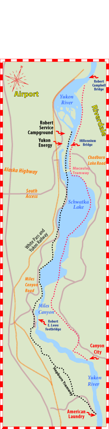
A closer look at sections of the Hepburn Tramway
American Laundry, site of the start of the tramway
- This was the upstream terminus of the tramway. With the various building remains here, it's perfect for interpretation: A First Nation landing for a portage around the canyon and rapids? An 1898 map showed an N.W.M.P. post and stables. We assume the laundry aspect refers to its role during the war. What were the later industrial activities such as a water pipeline back to Whitehorse Copper? It looks like there's lots of opportunities for photo and story research.
- Brushing out the entrances to both the Hepburn Tramway and the Escarpment Trail (follows along the river) are easy initial steps.
- Some City plans mention the possibility of creating a boat launch here.
- The American Laundry road can get in rough shape with lots of rain.
Upstream terminus to parking access road at Miles Canyon
- This section will be a very desired trail. There's almost 3 km of tramway in fairly usable shape. Most people have not walked much of the area of the Hepburn Tramway south of Miles Canyon.
- Keep the current character of the mossy old tramway. Look at the Macaulay Tramway for how characterless the tramway can become. A cross-section excavation would make a valuable interpretation story. How long ago was the fire? 1880s? Was fire-killed wood used as rails?
- The Escarpment Trail (along the river opposite Canyon City) starts at the American Laundry site. Hepburn Tramway upstream is a 6.3-km figure 8 loop trail that showcases this area.
- About 3/4 km needs initial brushing and/or shovel work. A second stage would be to fix the pieces overrun by industrial activities and where trees have grown up in the original route.
- Follow the coming application to turn the area on the other side of the tracks into a gravel quarry.
- Tell more of the story of Joni MacKinnon's riding stable and her fight to recognize and preserve the tramway.
- The City's Historic Sites' map shows an heritage area near where the tramway crossed the American Laundry Road. What is this?
- What is the story at the lower landing around being a second entrance to the tramway? Were the tents/tent frame in early photos for landing staff? Were they anything to do with the telegraph line? Photos show a black area below the tent frame. Was this a cellar? Or a stable?
- What was the story behind the pumphouse–pipeline going back to the lot in the Utah site? Are there photos of the road that descends from the railway — a pipeline construction road? — that resulted in covering a section of the tramway?
- This is also a good area to talk about both the railway and its rerouting here, as well as the oil pipeline route.
Miles Canyon parking area
- In this section, the tramway route has been completely displaced by road access to the parking lot. Interpretation is needed for the spur line, pump house and for community recreation.
- The section the Yukon River Trail Marathon uses to descend to the canyon is very slippery.
- Stairs down to the suspension bridge are not accessible. Making the connection into Miles Canyon inviting, wheelchair and senior-tourist friendly will add to it's popularity.
Parking area to where the Miles Canyon Road descends to Schwatka Lake
- Just past the parking lot road, there's about 2 km of original tramway route mostly in place. The existing tramway that runs from below the lookout to the start of the goat trail needs a makeover. It gets used as part of the Yukon River Trail Marathon and could be made safer, more inviting.
- Slope stabilization at the Goat Trail hill could be a feature attraction. This will allow recreational users to skip the dangerous Miles Canyon Road between Miles Canyon and Schwatka Lake. Would be an ideal community project as it would need constant monitoring, watering for a number of years. A school science or environmental class?
- The tramway at Goat Trail hill needs restoration partly because of its earlier reuse as a road for cars! Are there any stories about this? Did the road collapse while it was being driven? Can we make a map of the various iterations of Miles Canyon 'Boulevard'? (Where else could early cars go from Whitehorse? dates?)
- The Goat Trail will likely be a difficult restoration to be long-term sustainable. Is there a way to bypass this slope using a gentle climb on another part of Goat Trail hill? Would it be feasible to run a gabion along the water's edge and have the trail run along it?
- The section between the Goat Trail hill and where the Miles Canyon Road descends to Schwatka Lake needs a bit of brushing and signage.
Cora Grant's cabin to Robert Service Campground
- Apparently her cabin was along the river in the area that had to be moved because of the dam. Enjoying Whitehorse Trails says "built on the edge of the meadow that became Schwatka Lake." Cora says she was told it was a N.W.M.P. cabin. The 1899 Lyons railway survey map shows three buildings at the foot of the rapids. A 1898 Hegg photo refers to N.W.M.P. log cabins in a photo at that spot. Was Cora's cabin was originally located in today's Robert Service Campground? Is it one of the N.W.M.P cabins? Cora has a lifetime lease on the spot where the cabin is. Then what? Could the cabin and the grounds become a museum outpost?
- The tramway used to run near the river, but it's almost all lost under Schwatka Lake, the Miles Canyon Road, and the Yukon Energy dam. Now walkers, runners and mountain bikers jostle with motor homes and tour buses. At one time this area was mostly within the Chadburn Lake Reserve. Somehow the road became more important? The solution: an almost 3-km-long promenade starting at the campground. A simple path should be quite adequate? With the likelihood of water levels being raised for generation capacity, the path should be on the land side, not the lake side.
- Interpretation opportunity here is obviously the story of air travel and float planes.
- Getting past Yukon Energy could be made better. Extending the current River Marathon trail through the woods to the LNG plant would bypass a walk along the road by the spillway.
- Follow the process as the Ear Lake quarries leases expired end of 2016. This area is important for creating loop trails for this segment of the Hepburn.
Robert Service Campground
- The tramway ended at White Horse Rapids; one 1899 map shows a spur line to the area of the Highway Pull-off with the eagles' nest. Here's a great interpretation opportunity featuring tramways, rapids and walking loops that will encourage people to set off along the lake.
- What about First Nation fish camps and routes to go back to Fish Lake area?
- Are there archival records in Yukon Energy's library that could tell more Tramway story? Interpretation here could also tell about building the dam, the LNG plant, the power grid....
- There must be some record, written, photographic or oral, about Robert Service Campground and the tramway.
Other thoughts
- Many trails on the east side by the canyon are part of the Chadburn ski trail network making walking opportunities confusing. Having good walking on the west side makes sense. Designating an all-season walking trail would be nice and would also allow winter access to the tramway from the east side.
- Move the winter closing gate at the highway and Miles Canyon Road along the road and create a parking lot so people can easily access Miles Canyon and the tramway during winter closure.
- A goal should be that people walking the Yukon River trail can walk the trail in shorter segments, either by leaving a vehicle at each end of a segment, or by creating loops with each segment. Area trails can be incorporated into loops.
- Trails around Ear Lake can be used for loops.
- The Schwatka Lake loop is a nice loop.
- The Millennium Trail is a popular loop.
- The area between the tramway and the canyon is hilly and has a majestic forest feel, especially the escarpment slope. It would offer a great opportunity for an organization to offer interpretation, somewhat like YCS does on the east side of the canyon. This is an area that dirt bikes started to use a bit. Perhaps the area around the old Ear Lake quarries might be more suitable. The problem with making the Miles Canyon area a dirt bike playground is that the trails will quickly get unusable and more of the area will be developed, making the future of the area a series of hilly eroded ruts. Once the current riders move on to more exciting riding, the area will be unattractive for decades.
- Imagine if, at least in the summer, there were bus stops along the highway such as at the highway end of the Miles Canyon Road, The American Laundry Road, Wolf Creek Campground,... One could walk from town and take a bus back, or take a bus out and walk back.

 Hepburn and Macaulay tramways