Mountainview – Range Road trails
Have a glance at these whitehorsewalks pieces to see how Range Road planning affects a vision of a Yukon River Corridor Trail.
- A walker's look at Whistle Bend
- A walker's look at downtown–Marwell
- Yukon River Corridor Trail
- 5 City centre loop trails
January 14, 2014 Background document for upcoming Range Road Planning process is now available.
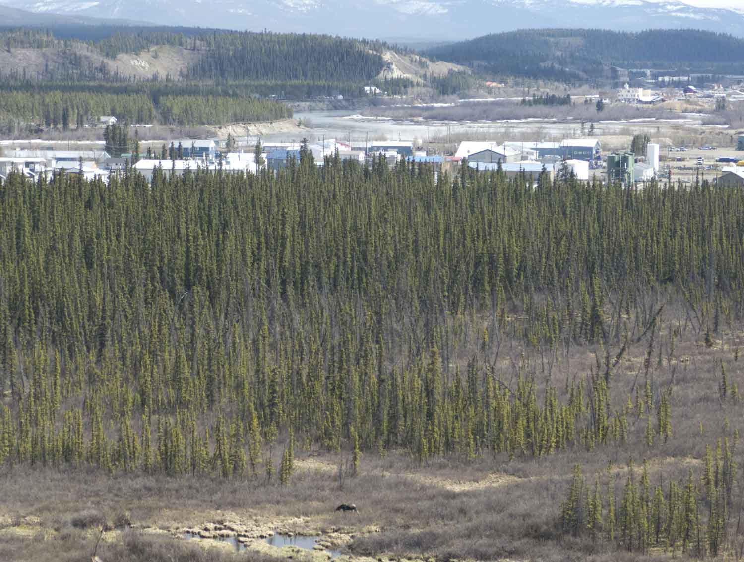
The neighbourhoods of Takhini Trailer Park and Kwanlin Dun's C194-B subdivision back onto the high bank above the Marwell Wetlands. Moose, bear, eagles have all been seen in this area. Mountainview Place borders the escarpment above the Yukon River. The north end of this area looks out over the confluence of the Yukon River and McIntyre Creek, an area previously used as a dump. The area has been significantly rehabilitated with the leadership of the Ta'an Kwäch'än First Nation.
Looking at the area in a broader picture, if the city wants to encourage more walking, then the trails need to become formalized and fixed up.
Peter Long, July 2013.
(click maps for larger versions)Understanding the lands under study
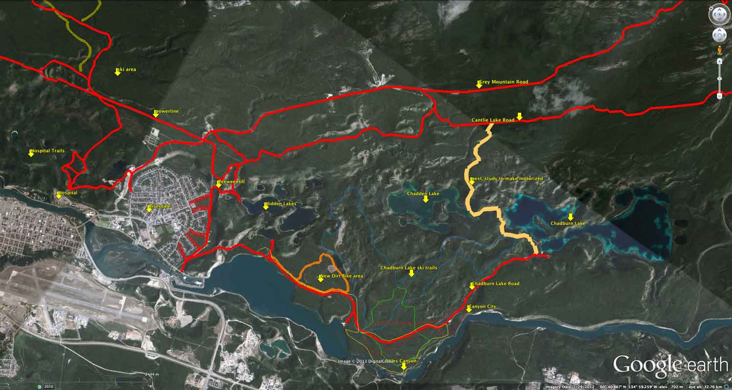 The Area of Interest planning map (first map on right) needs additional explaination for the land being looked at for this planning process. What looks like lots of lovely greenspace, is actually steep slopes and river lowlands.
The map at the far right is from Map 9:
Lower McIntyre Creek - Yukon River
from Defining Ecologically-Based Significant Wildlife Areas for
the City of Whitehorse.
This report describes the area along the river as High Environmental Sensitivity: Very steep, forested slopes directly adjacent to the High Wildlife Values.
It's important to understand this because this residential area will have an initial strong focus on the upper level of the escarpment for major trails.
The Yukon River Corridor Trail depends on trail decisions made for this area
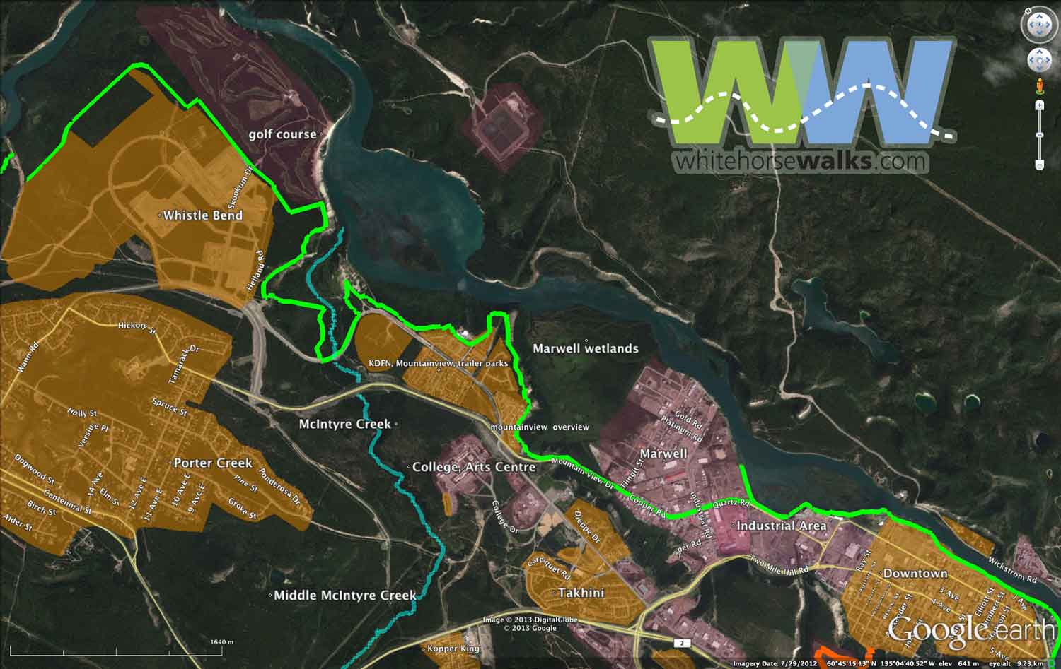 In this map, brown shading is residential or future residential, and reddish-purple shading is other land uses. The green line is the future Yukon River Corridor Trail. One day, if we plan it right, we will be able to walk along the river, from the Yukon River Bridge to the Takhini River Bridge. While many parts of this route exist, the area from downtown to past Whistle Bend is still only an vision, an opportunity for the city to develop a trail.
With significant segments of this proposed trail passing over Kwanlin Dun lands, their participation is mandatory.
The Mountainview – Range Road area is obviously an important part of the route. As Whistle Bend fills to its projected 8,000-10,000 residents, the need for recreational trails heading downtown will become a big issue. The river trail will also be quite important for Porter Creek walkers.
Specific Trails
McIntyre Creek, College to Yukon River Lookout
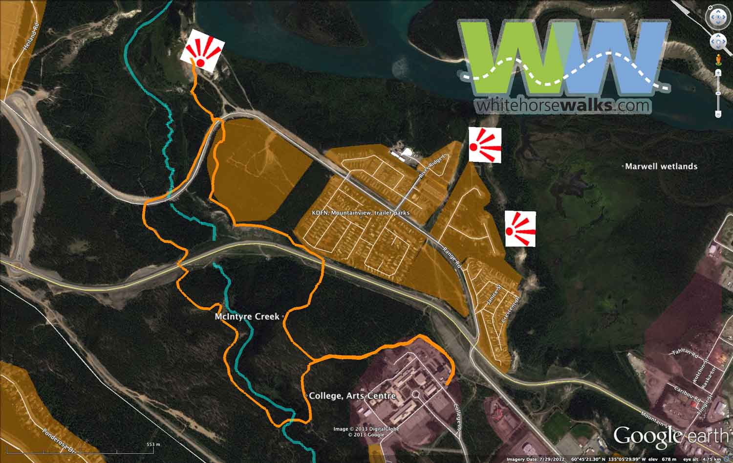 This second map shows a close-up of the Mountainview – Range Road area. The orange trail is about 6.25 km, starting at the Yukon Art Centre's outdoor sculpture garden. It follows the height of land above McIntyre Creek to the signed viewpoint at the confluence of the Yukon River and McIntyre Creek. There's interpretive signage errected here.
Mountainview/College Wetlands Viewpoint Trail
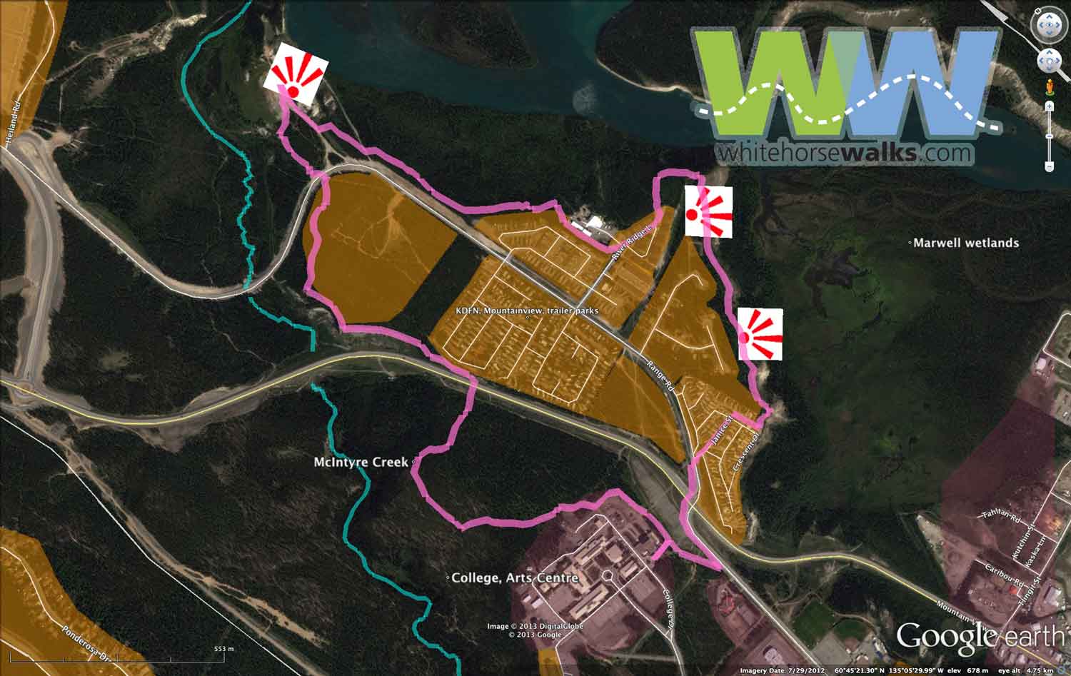 This third map shows, in pink, a third nice trail, 6.2 km long, again starting from the sculpture garden. It has a few spectacular viewpoints along the way. This loop will be well used by Mountainview – Range Road residents. I talk more about it here on the favourite walks page.
Middle McIntyre Creek walking trails
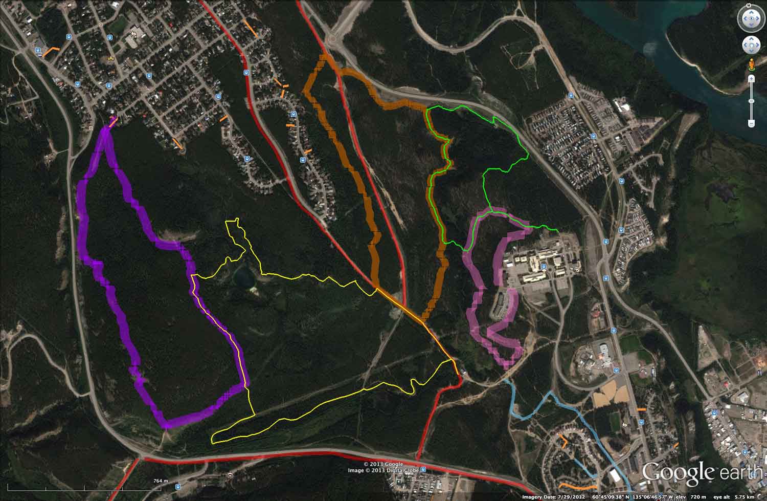
There are 5 specific walking trails now in the middle McIntyre Creek area. The Boreal Worlds trail (shown in pink) at the college was recently updated to accommodate the new housing buildings that usurped the original trail.
Friends of McIntyre Creek, Yukon Conservation Society and the City have mapped 4 new walking trails (purple, yellow, brown and green) in the area between Mountain View Drive and the Alaska Highway.
These trails will be important destinations to residents in the Range Road planning area and it is unlikely that most of the residents would walk all the way down to the traffic lights at the Mountainview/Range Road intersection to be able to walk these trails.
The trails will also be important to Whistle Bend residents (projected to be >8000 residents). Obviously road crossings for pedestrians need to be well thought out.
Range Road neighbourhood walking map


Left shows concentric circles, .25 km apart, centered at corner of Range Road, River Ridge Lane (thick blue are proposed to be paved, pale greenish blue are paved. Right shows some of the area trails. Think of walking about 4 km per hour for a moderate pace. Trail colour legend:
- blue — College – creek – dump: 6.2 km
- pink — College – viewpoints: 6.2 km
- purple — Big Bend neighbourhoods: 3.3 km
- yellow — Northlands – College pond: 4.1 km
- pale orange — trail needed
- pale greenish blue: paved city trail
- ICONS—red binoculars: viewpoint; 2 people: crosswalks; small square: bridge; red triangle "!": unmarked crossing, take care; circled "?": bridge needed, trail routing problem
A big problem is whether the mountainview crossing by Northland can be done. If Mountainview is twinned and divided, crossings are much simpler. An automatic island in the middle!
Current and proposed road and creek crossings
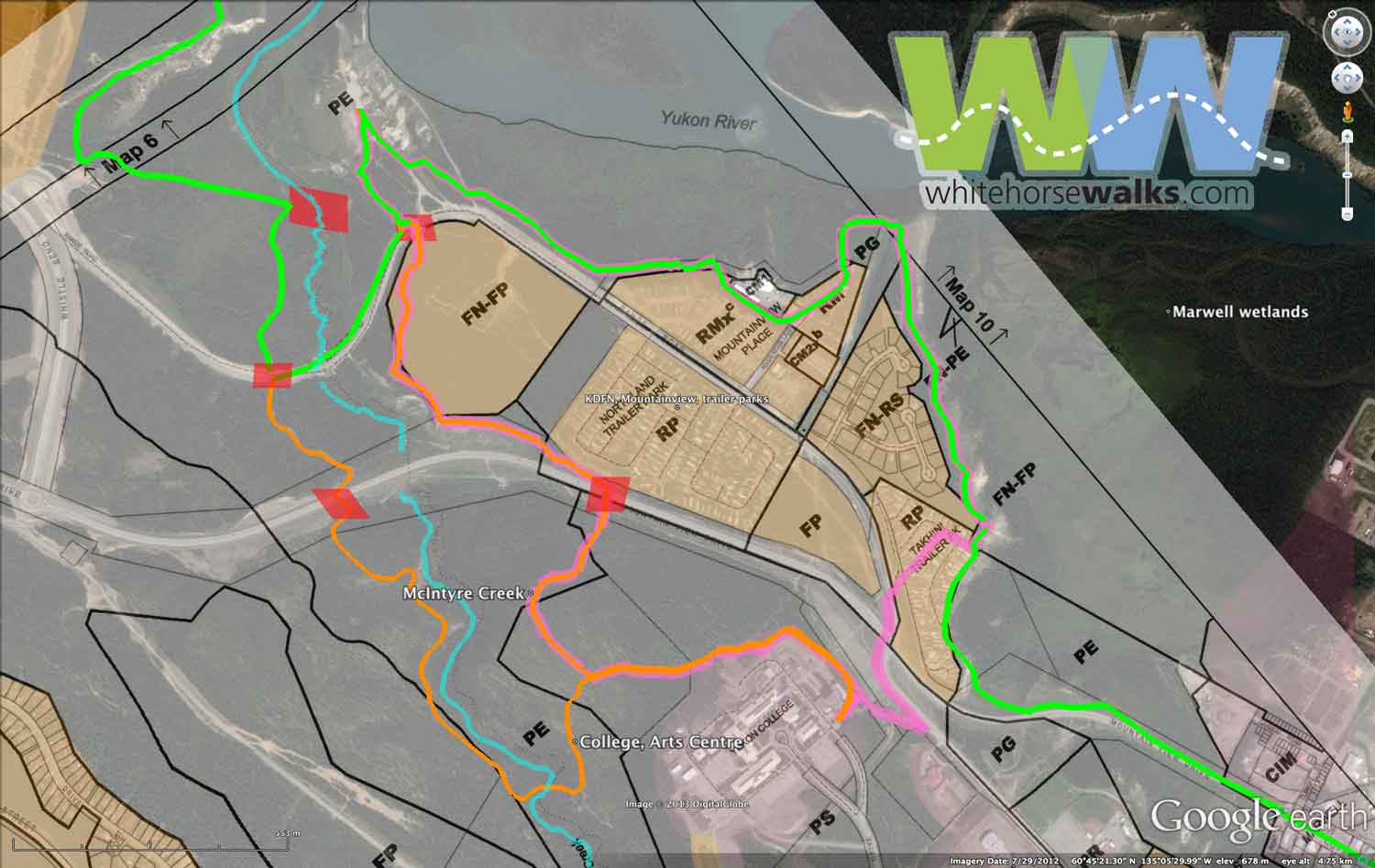 To make these trails possible, now is the time to look at zoning and roadway crossings in the area. The trails are shown using the 2012 Zoning By-law's Map 8: Yukon College, Mobile Home Parks as a transparent layer.
The parts of the trails along the river and creek generally are following the edge of the height of land, usually with a fairly sharp slope down to the creek, the river or low land down near the river.
The red spot on McIntyre Creek shows where the Yukon River Corridor Trail could cross McIntyre Creek with a small bridge, opening up Mountainview's access to Whistle Bend and its new Eagle Bay Park (not shown on this map). Likewise, Whistle Bend residents would be far more likely to see walking as a recreational pursuit. This crossing, likely the site of an earlier road, would be an attractive spot, much like the bridge below the college.
The other red spots are road crossings, two on Range Road, and two on Mountainview Drive. While it is easy to dismiss these crossings and say "walk along the road, cross at the lights," this would miss a chance to encourage more walking. No doubt, active transportation will one day look at paving a trail along the side of the road, but it's important not to ignore recreational walkers.
With these crossings, Mcintyre Creek Park will become a walking destination. The city will gain a great step forward in looking at the health of its citizens.
Zoning and trail planning
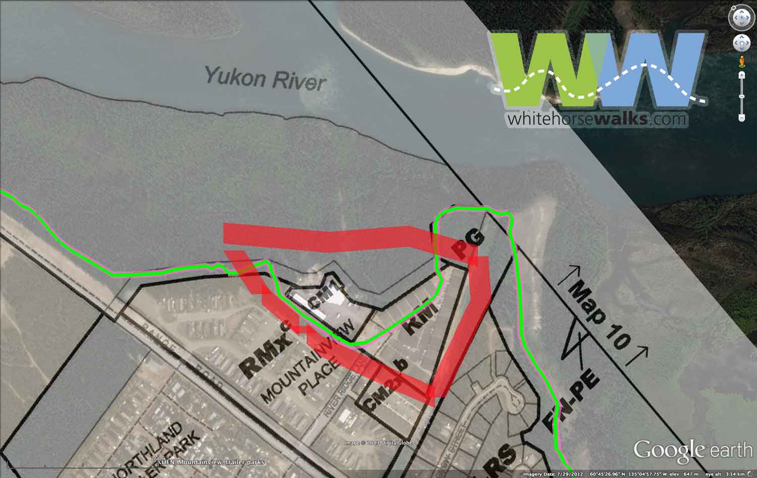 This industrial property (outlined in red) is overflowing the embankment. While there is a trail down and along the river, people wanting to stay up high wouldn't follow it. Here's a case where a greenspace network plan would have come up with solutions that could be implemented before the subdivision development happened.
Talking to residents in the area about trails showed that they were quite unfamiliar with where they could walk. Hopefully this planning process rights this situation. The likelihood of residents having a neighbourhood association that speaks for the variety of developments in the area is small, at least in the forseeable future.
Crossing Marwell wetlands and industrial area
 The Mountainview – Range Road trails depends on what happens as residents try to walk towards downtown.
Two larger issues. First, the route through the Marwell area really needs work. There are three possibilities shown here: the current green route that follows Mountainview Drive as it turns into Industrial Road; this current way is quite unappealing as a walking route, likely also as a cycling route. There are two potential routes, marked as orange and red.
The red trail designated as 'active transportation plan' is the city's active transportation plan proposed route through the heart of the industrial area. This route will be fine for people in a hurry, bicyling to and from work.
However, the orange route marked as 'Waterfront Nature Trail' presents an opportunity for wildlife viewing, a trail along the river for recreational walkers and interpretation. A significant portion of this goes through KDFN land and will obviously be subject to their needs and timelines. As this route goes along the edge of the wetland and the edge of the Yukon RIver, it will be far more interesting for recreational walkers and tourists. Dog walkers from the animal shelter in Marwell will rejoice in not having to walk on a dustry gravel road.
The second larger issue is how the trail along the escarpment gets onto Mountainview Drive. The current way is to walk through Takhinni Trailer Park, then follow the side of the road down the hill to Marwell Industrial area. The orange route is a good opportunity for a trail crew to make a more interesting descent to the wetlands.
The growth of the condos downtown also means many more downtown residents are looking for places to walk. With Kwanlin Dun's Cultural Centre on the waterfront, the opportunity to combine walks and interpretation to this area presents itself as an interesting way of sharing First Nation culture. I've also addressed this on my Marwell page.
As the city grows and becomes more skilled in trail building, a route down to the mouth of Marwell Creek and a pedestrian footbridge there would be a natural step in creating a walking destination for the area.
Range Road area planning process (2009)
 At the right is the area's 2009 brainstorming map from the lead-up to the 2010 OCP.